Directions to Higher Pursuits
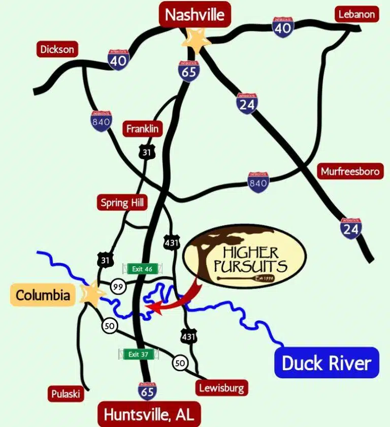
Higher Pursuits is located just minutes away from downtown Columbia, TN on the Duck River. Our office and canoe base conveniently located less than an hour from Nashville and Murfreesboro, 30 minutes from Franklin and just over an hour from Huntsville, AL. The check-in for all trips is at this location. We do have parking, but have limited spaces so, if possible, carpooling with other group members is always helpful.
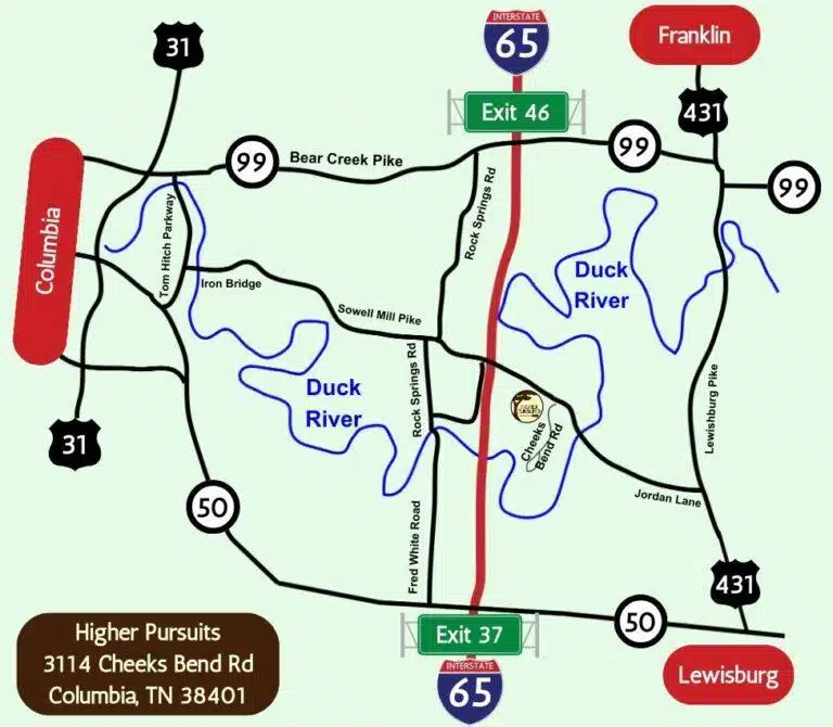
Our Address: 3114 Cheeks Bend Rd, Columbia, TN 38401
Conveniently located less than an hour from key cities in Middle Tennessee
Directions from cities to our North
If you are traveling from cities to our north such as Nashville, Dickson, Franklin, etc. the easiest way to reach Higher Pursuits is by traveling south on Interstate 65 and taking Exit 46 (Highway 99 – Bear Creek Pike)
If you are traveling from Murfreesboro, you will need to take Interstate 840 to Interstate 65.
- At bottom of exit 46 ramp turn Right
- Go 0.7 miles and turn Left onto Rock Springs Road
- Follow Rock Springs Road for 3.5 miles
- When you reach Sowell Mill Pike turn Left
- Go another 2.7 miles on Sowell Mill Pike (you will cross over I65)
- Turn Right onto Cheeks Bend Road (You will see our sign by the road)
- We are immediately on the right-hand side of Cheeks Bend Road
Directions from cities to our South
If you are traveling from cities to our south such as Lewisburg or Huntsville, AL the easiest way to reach Higher Pursuits is by traveling north on Interstate 65 and then exiting at Exit 37 (Hwy 50 towards Lewisburg). At the top of the exit ramp turn right.
- Go 5.9 miles and turn Left onto N Franklin Pike (US 431) (there is an Exxon Station on your left
- Go 5.3 miles and turn left onto Jordan Lane (house with painted rock in yard)
- Go 3.2 miles (you will cross over the Duck River and road becomes Sowell Mill Pike)
- Turn Left onto Cheeks Bend Road
- We are immediately on the right hand side of Cheeks Bend Road

Directions from Columbia and other local areas
In the summer of 2025 Tom Hitch Parkway between Bear Creek Pike and Iron Bridge Road will be closed for repairs.
There are several other route options to reach Higher Pursuits.
The first option is to take Bear Creek Pike (Hwy 99) towards the interstate. Turn Right onto Rock Springs Road. You will follow Rock Springs Road for 3.5 miles. When you reach Sowell Mill Pike turn left. Go another 2.7 miles on Sowell Mill Pike (you will cross over I65). Turn Right onto Cheeks Bend Road (You will see our sign by the road). We are immediately on the right-hand side of Cheeks Bend Road.
Another option is to take Hwy 50 towards Lewisburg, then turn left onto Tom Hitch Parkway. Follow Tom Hitch until you reach the light and turn right onto Iron Bridge Rd. Follow Iron Bridge for 8 miles (Iron Bridge turns into Sowell Mill Pike). Turn right onto Cheeks Bend Road (you will see our sign).

Directions to Henry Horton State Park (approximately 25 min)
- From the Park Inn – turn Right onto US 31A
- Go 0.7 miles turn Left onto Hwy 99
- Continue 7.2 miles and turn Left onto Hwy 431 (River Rats is on your left)
- Go 4.8 miles and turn Right onto Jordan Lane (house with painted rock in yard and there is also an Antioch Church of Christ Sign)
- Go 3.2 miles (you will cross over the Duck River)
- Turn Left onto Cheeks Bend Road (dirt road)
- We are immediately on the right-hand side of Cheeks Bend Road
We look forward to seeing you at the Higher Pursuits Canoe Base!


